
Nearest train station: Stanhope/Bishop Auckland
Derwent Reservoir, County Durham (not to be confused with its Derbyshire namesake), lies just outside the village of Blanchland. It actually straddles the border between County Durham and Northumberland (though we’ll let it fall under our County Durham section this time!) and offer visitors activities aplenty in the form of sailing, windsurfing and of course open water swimming.
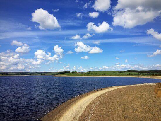
The large body of water is one of England’s largest reservoirs and is also popular with hikers and campers. Given the breadth and depth of the reservoir, open water swimming at Derwent Reservoir forms a much more watersports-like experience and is managed by the Derwent Reservoir Sailing Club: you can’t simply rock up and jump in. Open water swimming at the reservoir is only available from spring through to October and you will need to get in touch with the club to book a spot.
Regardless – Derwent Reservoir offers the more serious open water swimmer a rewarding experence and the surrounding natural beauty can’t be beaten. The swim course at Derwent Reservoir is roughly 200 metres long, and swimmers must wear a swimming hat and swimming wetsuits are encouraged.
How to Get to Derwent Reservoir County Durham
We’ve provided detailed instructions on how to get to this stunning reservoir by various means of transport below, as well as general travel information nearby.
By car
Enter the postcode DH8 9PT into your sat nav, which will take you to the Derwent Reservoir Sailing Club car park. Parking here is free for both members and visitors.
The club lies just off School Lane, a couple of miles west of the A68 turning near the hamlet of Caterway Heads.
By public transport
It isn’t generally recommended to get all the way to Derwent Reservoir by public transport given the size of the place. There is a bus stop at Pow Hill County Park, however this will leave you on the wrong side of the reservoir.
Trains will get you as far as Bishop Auckland (about 20 miles south) and you’ll then have to traverse the Weardale Railway, a heritage service with a limited timetable (although you’ll enjoy stunning views along the way). This will only get you as far as Stanhope however, which is still a good 10 or miles from the reservoir.
Overall, it’s probably best to arrange a taxi to the reservoir from your train terminus if you’re coming without a car of your own.
By bike
There are several cycle routes around Derwent Reservoir. There’s the Derwent Walk, a waymarked route of 11 miles that follows the reservoir’s shoreline. Find out more about this route from a cyclist’s perspective.
The reservoir is easily accessible by bike via the B6278 and B6306 roads (to name a couple) if you’re coming up through rural County Durham, and the nearby town of Consett (just east of the reservoir) also offers a good set off point.
What else is near Derwent Reservoir?
There’s so awful lot of natural beauty surrounding the reservoir that you could spent days over repeated visits taking everything in.
Whether it’s fishing, sailing, hiking, bird watching or glamping, the area ticks a lot of boxes in terms of outdoor activities. Further south, the North Pennies AONB offers much more in the way of hiking and stunning landscapes coupled with a few wild swimming waterfalls to boot – namely Low Force waterfall.